Call Us: + 323-240-2303
Email Us: sbuiloff@builoff.com

Call Us: + 323-240-2303
Email Us: sbuiloff@builoff.com
Licensed land surveying for Altadena, ZIP 91001 - built around the Eaton Fire rebuild. Boundary surveys, post-fire topographic mapping, oak-tree-aware boundary work, construction staking, and the existing- conditions content the LA County DPW Building & Safety + Department of Regional Planning team needs at the Altadena One-Stop Permit Center.
Services
ALTA/NSPS Land Title Survey
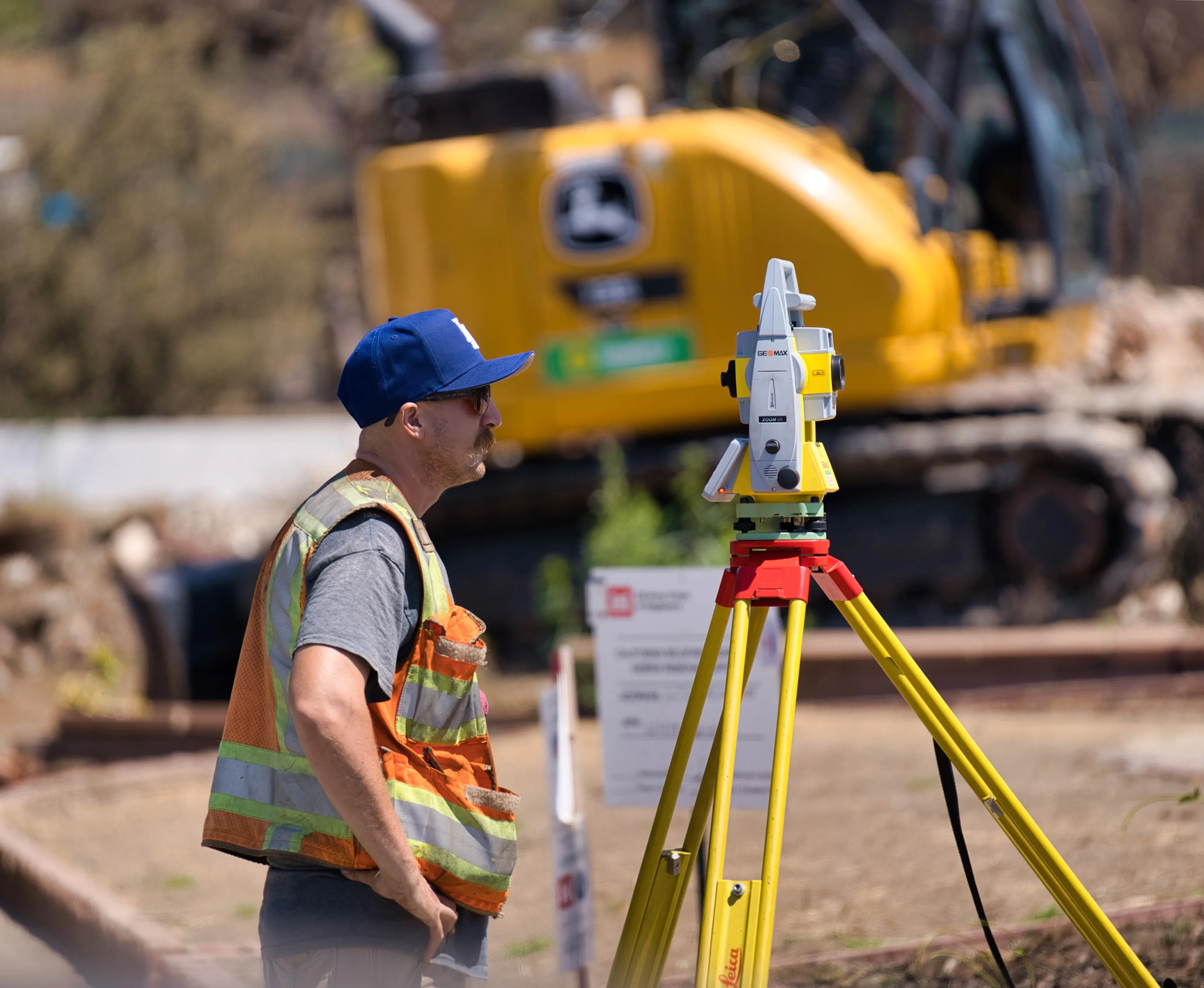
Topographic Survey & Map (3D)
Boundary / Property Line Survey (Lot Line Survey)
Construction Staking / Site Layout (Construction Layout)
Setback Verification (Foundation Forms Check)
Altadena is unincorporated. There is no City of Altadena. The community sits directly north of Pasadena in the San Gabriel foothills, inside ZIP 91001, with about 42,800 residents across roughly 8.7 square miles at a density near 5,060 people per square mile. Median home value sits near $1.13 million and many homes were built before 1939 - older Craftsman and Spanish lots, smaller and denser than the hillside parcels in Calabasas or the Palisades, but with foothill topography rising sharply to the north.
Because Altadena is unincorporated, every requirement comes from Los Angeles County, not from a city. Two County departments do most of the permit work:
The January 2025 Eaton Fire destroyed a large portion of Altadena's housing stock and reset most surveying scope in the area around fire-rebuild needs. A few characteristics of Altadena that drive surveyor scope:
The first step on most Altadena fire-rebuild projects. LA County's published Fire Rebuild FAQ states explicitly that prior to the start of construction, most rebuilds will require a survey to identify the property boundaries. We deliver traverse closures, monumentation found and set, full bearings and distances, and ties to street centerline monuments. Whenever permanent survey monuments are set or referenced on site, we file a Corner Record with the LA County Surveyor per California Business & Professions Code §8773 - the Corner Record is the required DPW filing that documents the monumentation, not a separate service. (A Corner Record and a Record of Survey are distinct documents under the Surveyor's Act; the Corner Record is the appropriate filing for monumentation set or referenced as part of a boundary survey.)
Particularly useful in Altadena, where neighboring parcels often share block-scale topography and a single UAV flight can serve a row of adjacent rebuilds. UAV photogrammetry or UAV LIDAR, ground-controlled to NAVD88, filtered to a bare-earth surface, and delivered as a stamped topographic survey at 1-foot contour interval (hillside) or 2-foot (gently sloped foothill). Trees plotted per LA County Title 22 Part 16 thresholds.
LA County DPW Building & Safety + Department of Regional Planning content. Boundary plotted from a current legal description and current preliminary title report; property lines, yards, and setbacks per LA County Title 22; building footprints and heights; existing improvements; easements of record; oak trees plotted with protected zones; CSD-relevant items (fence/wall lines, landscape setback lines) shown on Eaton Fire-area parcels. Pre-Approved Standard Plan adaptation uses this plot plan as the site-specific input.
Sources: LA County DPW Building & Safety · LA County Title 22 (Zoning) · LA County DPW - Obtain Permit After the Eaton Fire.
Existing-condition topographic mapping for design teams working in Altadena. 1-foot contour interval is standard for foothill / hillside lots; 2-foot is acceptable on gently sloped sites. Spot elevations at structure corners, top and bottom of walls, ridge points, top of curb, flow line, and edge of pavement. Vertical datum stated; NAVD88 typical. Easements of record from a current preliminary title report.
Trunk location plotted to center, species labeled, DSH labeled per trunk, single-trunk vs multi-trunk identified. Protected-zone geometry plotted: drip line plus 5 feet, OR 15 feet from trunks, whichever is greater - LA County Department of Regional Planning's Oak Tree Diagram is explicit: "Show BOTH on site plan." Even Like-for- Like rebuilds must respect the oak-tree protected zone - rebuilds that encroach require an Oak Tree Permit.
Source: LA County Title 22 Part 16 - Oak Tree Permits (PDF).
Required by LA County on hillside development projects in the foothill zones north of Altadena Drive and Loma Alta Drive. Built directly off the topographic survey. Categories used in LA County hillside review are project- and zone-specific; the County Department of Regional Planning typically calls for the same 0-15% / 15-30% / 30-45% / 45-60% / 60%+ bands used across the surrounding region. Tabulated by square footage with contrasting color or hatching.
For commercial real-estate transactions, refinances, and lender / title insurer requirements on Altadena commercial assets and high-value residential properties. Current 2021 Minimum Standard Detail Requirements for ALTA/NSPS Land Title Surveys; the 2026 standard takes effect February 23, 2026. Table A optional items selected per client.
Required before the LA County DPW Building & Safety foundation forms inspection. Our licensed surveyor sets offset stakes referencing future building corners or the property line adjacent to the corner, with at least one NAVD88 elevation hub. Additional offset stakes commonly set at: edge of the LA County oak-tree protected zone (drip line + 5 ft, OR 15 ft from trunk, whichever greater); CSD-required setback lines; Like-for-Like rebuild footprint corners that match the prior structure (so the inspector can confirm the like-for-like condition). Construction- staking exhibit on 8.5″ × 11″ page format delivered to the contractor for the foundation forms check. We can combine the construction staking and the boundary survey field work in one efficient visit on most Altadena projects.
Performed at the foundation form stage, before concrete is placed. Verifies all front, side, rear, and street-side setbacks against the approved zoning report, plus oak-tree protected-zone setbacks (LA County 5-ft / 15-ft rule), Altadena CSD setback standards on Eaton Fire-area properties, and any Like-for-Like rebuild conditions tied to the previously-approved structure footprint. Deliverable is a surveyor- stamped form certification or marked form survey.
Height limits set by LA County Title 22 zone and any Altadena CSD overlay. Surveyor-stamped roof-height certification at framing/sheathing inspection commonly requested on hillside Altadena projects. All elevations on a stated datum (NAVD88 typical).
LA County's eCheck AI Pilot for early-adopter Altadena single-family rebuilds expects a complete site plan as part of the upload - UAV-derived bare-earth topographic surveys are an efficient way to produce that plan across a contiguous block of fire-impacted parcels. Final deliverables tied to NAVD88 vertical and signed/stamped.
LA County DPW Building & Safety follows the LA County Building Code grading-permit closeout requirements. We deliver an as-graded plan signed and stamped by the design civil engineer or land surveyor of record, showing streets, pads, slopes, structures, original contours, finished elevations, and other information needed to accurately depict the as-graded condition.
Source: LA County DPW - Grading Plan Review Sheet.
We're active across all of ZIP 91001, including: Janes Village, Meadows, Country Club Manor, Altadena Heights, La Vina, Lincoln Crest, Mariposa, Sycamore Heights, Christmas Tree Lane (Santa Rosa Avenue), the Loma Alta Drive corridor, the Lake Avenue commercial corridor, and the foothill slopes north of Loma Alta and Altadena Drive that run up toward the Angeles National Forest.
No. Altadena is an unincorporated community in Los Angeles County, ZIP 91001, with about 42,800 residents across roughly 8.7 square miles. There is no City of Altadena. LA County DPW Building & Safety handles permits and inspections; LA County Department of Regional Planning governs zoning, the Altadena Community Standards District, and the Oak Tree Permit. Pasadena City rules do not apply.
LA County's published Fire Rebuild FAQ states explicitly that prior to the start of construction, most rebuilds will require a survey to identify the property boundaries. (The County's FAQ uses the phrase "corner record survey," but the Corner Record itself is the required DPW filing that documents any permanent monuments set or referenced - it is part of the boundary survey scope, not a separate service.) We file the Corner Record with the LA County Surveyor per California Business & Professions Code §8773.
Like-for-like rebuild projects can be approved with modifications that do not increase floor area, size, height, or building footprint by more than 10% or 200 square feet, whichever is greater (an Eaton-fire-area-specific rule). Like-for-like structures do not need to comply with current zoning, but must comply with current Building, Fire, and Health and Safety Codes. The surveyor's job is to document the prior footprint precisely so the design team can stay inside the like-for-like envelope.
Altadena is unincorporated, so LA County Title 22 Part 16 applies. Protected oaks: any single-trunk oak with 25″ or more in circumference (8″ in diameter) measured 4.5 feet above mean natural grade, or any multi-trunk oak whose two largest trunks have a combined circumference of at least 38″ (12″ combined diameter). Protected zone: drip line plus 5 feet OR 15 feet from trunk, whichever greater. LA County's Oak Tree Diagram is explicit: "Show BOTH on site plan."
The Altadena CSD is an LA County Department of Regional Planning overlay that governs setbacks, fences, walls, and landscaping in the Eaton Fire area. Even Like-for-Like rebuilds must comply with the CSD standards. Our plot plans show CSD-relevant items (fence/wall lines, landscape setback lines) so the design team has the existing-conditions baseline they need.
Yes. Many Eaton Fire rebuilds need both, and our field-to-finish automation lets us combine the field work - we set construction stakes for the foundation layout and monument the property corners as part of the boundary survey on a single visit. The contractor gets the construction-staking exhibit on 8.5″ × 11″ for the foundation forms inspection, and the Corner Record (the required DPW filing for any permanent monuments set or referenced) goes to the LA County Surveyor.
Send the address (or APN) and the scope you're working on - boundary survey, post-fire topographic survey, oak tree mapping, slope analysis, construction staking, or a combined scope - and we'll send a fixed written estimate. Sergei Builoff, MSc, PLS, California PLS 8099.
Phone: (323) 240-2303
Email: sbuiloff@builoff.com
We believe our services should exceed our customers’ expectations. By using modern technology and striving for constant improvement, we create real value in every project.
Los Angeles, Malibu, La Canada, Glendale, Pasadena, Pacific Palisades, Santa Monica, Topanga, Calabasas, Thousand Oaks