What makes surveying in Pacific Palisades different
Pacific Palisades is a Westside neighborhood of the City of Los Angeles - ZIP 90272 - with about 23,800 residents across roughly 10,800 housing units (about 7,000 single-family homes and 3,700 condominiums). Single-family lots range from compact in-fill parcels under 5,000 square feet up to 17,000-square-foot hillside and view properties. Topography is dominated by canyons (Santa Monica, Rustic, Lower Rivas, Santa Ynez), the 3-mile coastline from Santa Monica to the Getty Villa, and the Santa Monica Mountains framing the north and east.
In January 2025 the Palisades Fire destroyed thousands of structures, and surveying scope has shifted heavily toward fast post-debris topographic mapping, boundary surveys, bluff and canyon edge geometry, and the existing-conditions content the design team needs to apply Mayor's Emergency Executive Order No. 8 streamlined rebuild conditions. A few characteristics of the Palisades that drive surveyor scope:
- Coastal Zone overlay everywhere. Most of the Palisades is inside the California Coastal Zone, but Categorical Exclusion Order E-79-8 places most of the area under Single Permit Jurisdiction (LADBS only). The Dual Permit Jurisdiction strip drops to California Coastal Commission review on top of LADBS - a different deliverable scope.
- R1-1, R1V1, R1H1, RE zones. Most single-family parcels fall into one of these four zones, each with its own setback, mass, and encroachment-plane rules - rules that the surveyor's plot plan and topographic data have to support precisely.
- Hillside Area for most non-flat parcels. The Baseline Hillside Ordinance (BHO) drives a slope-band analysis (six bands), 1-foot contour interval as the working standard, and a height envelope keyed to "Hillside Area Grade."
- Bluff and canyon edges control geometry. EO8 streamlined rebuild conditions reference a 25-foot coastal-bluff setback and a 10-foot canyon-bluff setback - measured from the surveyed edge, not the property line.
- Like-for-Like rebuild path. EO8 lets eligible owners rebuild within the prior structure's footprint and envelope. The surveyor's job is to document the prior footprint based on available field evidence so the design team can stay inside the like-for-like envelope.
- Protected tree ordinance still applies. LA City's Protected Tree Ordinance (4-inch cumulative diameter, native oaks, walnut, sycamore, bay, Mexican elderberry, toyon) governs even on fire-rebuild parcels.
Surveying services for Pacific Palisades projects
Post-Fire Topographic Survey - Pacific Palisades
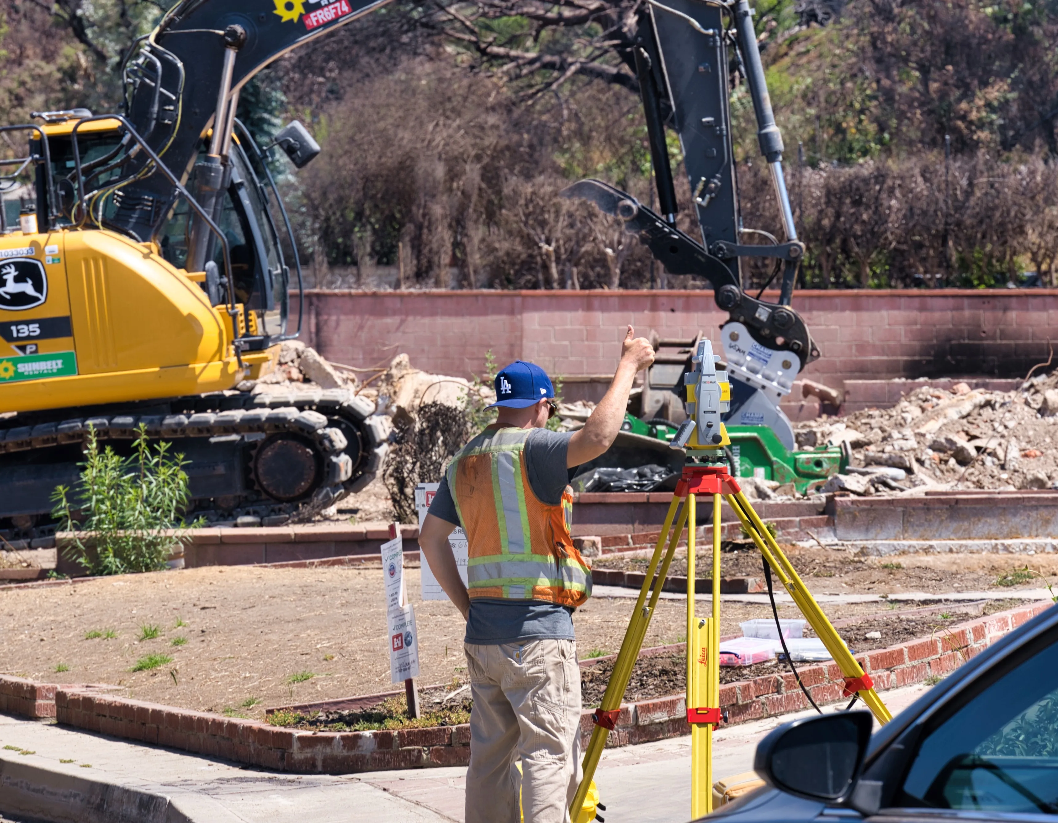
The most-requested scope on Palisades fire-rebuild parcels. UAV photogrammetry or UAV LIDAR over a contiguous block, ground-controlled to NAVD88 vertical and horizontal datum, filtered to a bare-earth surface, then turned into a wet-stamped topographic survey at 1-foot contour interval. We carry data from prior Palisades project areas forward to compress turnaround on adjacent parcels.
Boundary Survey - Pacific Palisades
Most Palisades fire-rebuild projects start with a boundary survey because debris removal frequently disturbs monuments and because LADBS rebuild guidance flags property-line verification as the typical first step. We deliver traverse closures, monumentation found and set, full bearings and distances, and ties to street centerline monuments. Whenever permanent survey monuments are set or referenced on site, we file a Corner Record with the LA County Surveyor per California Business & Professions Code §8773 - the Corner Record is the required DPW filing that documents the monumentation, not a separate service. (A Corner Record and a Record of Survey are distinct documents under the Surveyor's Act; the Corner Record is the appropriate filing for monumentation set as part of a boundary survey.)
Bluff Edge & Canyon Edge Survey - Pacific Palisades
A standalone product on bluff-front and canyon-edge parcels. We survey the top-of-bluff or top-of-canyon line per the LCP definition, plot it on the existing-conditions plan, and carry the controlling setback line (25-foot coastal-bluff or 10-foot canyon-bluff per EO8) through every downstream deliverable - slope analysis, construction-staking exhibit, setback verification.
Source: Mayor of LA - Emergency Executive Order No. 8.
Coastal Development Permit (CDP) Surveying - Pacific Palisades
For Dual Permit Jurisdiction parcels and any project that lands outside the E-79-8 Categorical Exclusion. We supply the surveyor's existing- conditions inputs the CDP application needs: topographic survey (including bluff/canyon edges and ESHA buffer geometry where mapped), boundary survey, slope analysis, public access easement geometry, view corridor lines, and any deed restrictions identified in the title report. OWTS plot plan, biological report, geotechnical report, Will Serve Letter, and Fuel Modification site plan are design-team deliverables; we provide the surveying inputs they rely on.
Sources: LA City - Zoning Information File ZI-2422 (Potrero Canyon area) · Categorical Exclusion Order E-79-8 (Pacific Palisades).
Slope-Band Analysis (BHO) - Pacific Palisades
Required for any permit application on a Hillside Area parcel - which covers most non-flat Palisades lots. Built directly off the topographic survey, with the six BHO bands (less than 15%, 15% to 30%, 30% to 45%, 45% to 60%, 60% to 100%, and 100% or greater) drawn in contrasting colors with a per-band area tabulation. Drives the Maximum Residential Floor Area calculation that LADBS verifies before issuing the permit.
Plot Plan / Site Plan - Pacific Palisades
LA City Planning content per CP-7752, plus Coastal Zone additions: the Coastal Zone boundary, the bluff or canyon edge with controlling setback, ESHA buffer lines, public access easement lines, view corridor lines, and any deed restrictions or offers to dedicate identified in the title report. Required BMP plot plan delivered separately on 8.5″ × 11″ format.
ALTA/NSPS Land Title Survey - Pacific Palisades
For commercial real-estate transactions, refinances, and lender / title insurer requirements on Palisades commercial and high-value residential assets. Current 2021 Minimum Standard Detail Requirements; the 2026 standard takes effect February 23, 2026. Table A optional items selected per client.
Construction Staking - Pacific Palisades
Same offset-stake-and-NAVD88-elevation-hub workflow we use across LA City, with extra offset stakes set on EO8 parcels at the 25-foot coastal-bluff setback line, the 10-foot canyon-bluff setback line, the ESHA buffer line, and any condition-of-approval setback. Construction-staking exhibit on 8.5″ × 11″ page format delivered to the contractor for the LADBS foundation forms inspection.
Sources: LA City Bureau of Engineering - Construction Staking Guidelines · LADBS IB-P-BC-2025-157 - Rebuilding in the Palisades.
Setback Verification (Foundation Forms Check) - Pacific Palisades
Standard front, side, rear, and street-side setback verification, plus the EO8 streamlined-rebuild bluff/canyon setback verification, ESHA buffer verification, and any public access easement set as a CDP condition. Surveyor-stamped form certification or marked form survey delivered before concrete placement.
Building Height Survey / Roof Height Certification - Pacific Palisades
Most Palisades non-beachfront residential structures fall under standard LAMC §12.21.1 height rules and, on hillside lots, the BHO "Hillside Area Grade" definition. Coastal-area projects also need to comply with any specific-plan height limits and the Coastal Act's protection of scenic and visual resources, which can drive view-corridor exhibits in addition to the standard certification. Surveyor-stamped letter delivered at framing/sheathing inspection.
3D Laser Scanning & UAV Mapping - Pacific Palisades
The fastest way to get an accurate baseline across a contiguous block of fire-rebuild parcels. UAV photogrammetry, UAV LIDAR, and terrestrial 3D scanning, ground-controlled to NAVD88, filtered to bare-earth, and delivered as wet-stamped topographic surveys, contours, slope analyses, and Scan-to-BIM models where the design team needs them.
Pacific Palisades areas we work in regularly
Pacific Palisades Community Council divides the neighborhood into eleven areas. We work across all of them, including: Lower Riviera, Upper Riviera, Huntington Palisades, Alphabet Streets, the Bluffs, the Highlands (Palisades Drive corridor), Marquez Knolls, Castellammare, Pacific Palisades Village, El Medio Bluffs, and the Santa Monica / Rustic / Rivas Canyon zone. The Palisades Highlands sit at higher elevation and have particularly steep parcels, so BHO slope analysis and 2-foot contour topographic data are routine there.
Authorities we coordinate with on Palisades projects
- LA City Recovery - Palisades Fire rebuild
- LADBS - Department of Building and Safety
- LA City Planning
- California Coastal Commission
- ZIMAS - check Coastal Zone, Hillside, Specific Plan, Categorical Exclusion
- Mayor's Emergency Executive Order No. 8
- LADBS IB-P-BC-2025-157 - Rebuilding in the Palisades
- LA County Surveyor (Corner Record / Record of Survey filings)
Frequently asked questions - Pacific Palisades surveying
Do I need a property survey to rebuild after the Palisades Fire?
LADBS rebuild guidance for the Palisades flags a property-line / corner- record survey as a typical prerequisite when records, monuments, or markers are missing or inconsistent. Even where a Grading Permit Inspection waiver is granted, the underlying property-line survey requirement is not waived. Most fire-rebuild owners want a fresh corner record before construction starts.
What are the bluff and canyon setbacks under EO8?
Mayor's Emergency Executive Order No. 8 conditions for Palisades streamlined rebuilds reference a 25-foot coastal-bluff setback and a 10-foot canyon-bluff setback. The surveyed bluff edge - not the property line - is the controlling feature; we plot it on the topographic survey and carry the setback line through to the construction-staking exhibit.
Does my Palisades parcel need a Coastal Development Permit?
Most Pacific Palisades parcels lie inside the California Coastal Zone, but Categorical Exclusion Order E-79-8 covers a large portion of the area, putting most parcels under Single Permit Jurisdiction (LADBS only). Some parcels are in Dual Permit Jurisdiction and require California Coastal Commission review on top of LADBS. The ZIMAS Coastal Zone field is the first place to check.
Can I rebuild "like-for-like" in the Palisades?
Yes - eligible owners can rebuild within the prior structure's footprint and envelope under EO8. The surveyor's job is to document the prior footprint precisely from record sources and field evidence so the design team can stay inside the like-for-like envelope. We can pull Sanborn maps, prior site plans, prior surveys, and assessor records to build that documentation.
How fast can BSM mobilize on a Palisades site?
We've kept Palisades data from prior project work in the area, and our field-to-finish automation lets us run UAV photogrammetry or LIDAR over a contiguous block, control to NAVD88, and deliver a stamped topographic survey on a tight timeline. Send the address or APN and we'll quote a delivery date in writing.
Get a Palisades rebuild estimate
Send the address (or APN) and the scope you're working on - boundary survey, post-fire topographic survey, bluff edge survey, slope analysis, construction staking, or a combined scope - and we'll send a fixed written estimate. Sergei Builoff, MSc, PLS, California PLS 8099.
Phone: (323) 240-2303
Email: sbuiloff@builoff.com
Surveying in Pacific Palisades
Pacific Palisades presents some of the most distinctive surveying conditions in Los Angeles County. Coastal bluffs, steep hillside lots, view restrictions, and high-value residential properties all demand accurate survey work and clear communication with architects, designers, and contractors.
We serve the Palisades across the full range of residential and light commercial needs — from property line questions and ADU planning to new home construction, hillside design, and fire rebuild support.
Supporting Palisades Rebuild Projects
The Palisades rebuild community needs survey work that moves quickly without compromising accuracy. We’re actively supporting property owners, architects, and contractors on rebuild projects throughout the area.
For rebuild work, we typically support:
- Topographic and boundary base maps for architectural and civil design
- As-built documentation of remaining site features and improvements
- Construction staking as rebuild projects move into construction
- Building height verification and setback confirmation for redesigned homes
- Slope analysis for hillside lots affected by fire conditions
Pre-collected aerial data in some Palisades areas
We have collected UAV aerial imagery and data over portions of Pacific Palisades, and in some cases this can accelerate turnaround for rebuild projects in those covered areas. Coverage is not comprehensive, and we can’t assume your specific lot is included — contact us with the property address and we’ll confirm what we already have for your location before scoping the full survey.
Common Projects We Support in Pacific Palisades
Beyond rebuild work, we support a wide range of Palisades residential and commercial survey needs.
- Boundary and property line questions — fences, walls, neighbor disputes
- Topographic and design base maps for architects and civil engineers
- ADUs, additions, and new home construction
- Hillside lot analysis, slope mapping, and grading feasibility
- Fire rebuild documentation and design support
- Coastal bluff properties and view-sensitive design projects
- As-built surveys for permit closeout and records
- Construction staking for foundations, building corners, and site work
Why Local Experience Matters in the Palisades
Hillside and bluff expertise
Palisades lots often involve steep grades, view restrictions, and complex site conditions. We work with hillside lots regularly and deliver surveys designed for hillside ordinance compliance and grading feasibility.
Fast response for rebuild projects
Our field-to-finish automation workflow accelerates map production, and UAV coverage in parts of the area can further shorten turnaround. Rebuild teams need speed without sacrificing accuracy — that’s what we deliver.
Licensed PLS oversight
Sergei Builoff, California PLS #8099, personally oversees every survey. No outsourcing and no project management layer between you and the responsible surveyor.
Local crews, Los Angeles knowledge
Based in Calabasas with 19 years of Los Angeles County work. Familiar with LA permitting, County recording, hillside ordinance, and the specific parcel conditions common in Palisades neighborhoods.
Services Available in Pacific Palisades
Full survey and mapping service range available for Palisades projects. Click any service for full details.
